Four ports with ample available industrial user real estate
Northernmost lock- and ice-free port on the Mississippi River
105 million tons of cargo through the region annually

Three Ports with Container on Barge Capabilities
The ports and barge industries within the St. Louis Regional Freightway are based centrally along the Mississippi River, within close proximity to America’s agricultural heartland, major Midwest populations and manufacturing centers. The St. Louis region is served by the six North American Class I rail carriers, the regional switching carrier Terminal Railroad Association of St. Louis (TRRA) and other short line rail carriers. The region’s cost-effective rail service and modal flexibility provide national reach, carrier reliability, reduced travel times and competitive transportation costs.
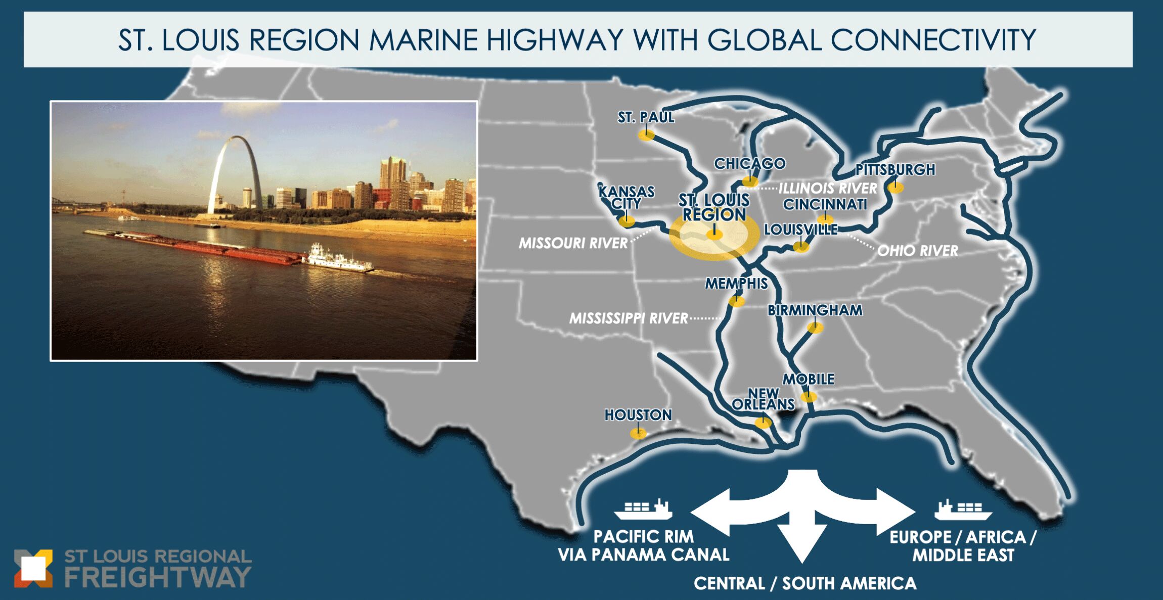
The St. Louis Regional Freightway’s port system includes both the Port of Metropolitan St. Louis and portions of the Port of Kaskaskia, IL. Our strategic location on the Mississippi River is the northernmost lock and ice-free port on the river and offers substantial fleeting operations. Efficiency has emerged as a hallmark of the region’s port system, which not only is one of the country’s largest inland ports, but also the most efficient. The St. Louis region’s port system is responsible for 70 of the 855 miles (8 percent) of the Mississippi River from Minneapolis, Minn., to the Ohio River near Cairo, Ill. These 70 miles carry almost a quarter of the river’s total freight, a direct reflection of the system’s efficiencies. The St. Louis region’s barge industry routinely handles approximately 369,000 tons per mile, while the average tons per mile across the other eight inland port districts is 92,863. Essentially, the St. Louis Metro Ports collectively move almost four times the average tons per mile, as compared to the other eight inland port districts in the U.S.
This activity takes place at the 200-plus private terminals operating within our region’s port system, each of which can be seen on our interactive map.
Want to learn about career opportunities on the inland waterways?
Check out WeWorkTheWaterways.com
Ag Coast of America
These strengths are even more evident along a 15‑mile stretch of the Mississippi River which has gained recognition as the Ag Coast of America. It is home to 16 barge-transfer facilities that, at total capacity, can handle more than 150 barges a day – the highest level of capacity anywhere along the Mississippi River. Currently, 50% of U.S. crops and livestock are produced within a 500‑mile radius of the St. Louis region, including approximately 80% of corn and soybean acreage. The St. Louis region’s strategic location on the river, infrastructure assets and multimodal connectivity enable it to play a crucial role in moving those commodities.

Ramping up for Container Market Growth
With the new wave of larger ocean carrier container vessels, projected global growth in the container market by 2030, and the emphasis to reduce truck traffic on the nation’s highway system, ports in the bi-state St. Louis area and other Midwest regions are working together to provide container-on-barge (COB) and a proposed container-on-vessel (COV) service. These efforts include ports investing in new equipment, repositioning of empty containers, channel deepening and other infrastructure investment.
Innovative container-on-vessel (COV) service on the Mississippi River and adjacent inland rivers would pair with COB service as part of a hub and spoke system that would serve key consolidation ports of the St. Louis region, Memphis, Tenn., and several other feeder ports. The Port of Herculaneum in Jefferson County, Missouri, has been identified as a hub for a key terminal in the proposed service. The COV service is part of a plan calling for patented new waterway vessels that will swiftly move large volumes of goods and commodities along the inland waterways, effectively creating an all-water north-south trade lane connecting the Midwest to the lower Mississippi River and on to worldwide destinations. The Jefferson County Port Authority’s acquisition of approximately 18 acres along the Mississippi River from Riverview Commerce Park, LLC (RCP) in fall 2024 supports these efforts. It is estimated that, once launched, shippers using the new service could see cost savings of 30–40 percent.
The Freightway’s four ports offer an abundance of industrial user real estate for commercial and industrial development.
America’s Central Port (ACP)
Located at the heart of the U.S. transportation network, with access to six Class-I railroads, four U.S. interstates, and two multi-modal harbors that sit near three U.S. inland rivers, America’s Central Port is one of the largest freight hubs in the Midwest. With industrial-grade utilities, Foreign Trade Zone designation, and excellent transportation infrastructure, the Port’s portfolio of development-ready sites and industrial real estate provides a supply chain and logistics advantage with which very few can compete. (Barge and Rail Services Provided 24/7)
St. Louis Port Authority
The St. Louis Port Authority represents the city’s 10,000-acre port district. It includes commercial, industrial, manufacturing and warehouse/distribution. The Port Authority also features Foreign Trade Zone No. 102, 22 interstate access points and BNSF, NS and UP main lines and rail yards.
Kaskaskia Regional Port District: KRPD 1 & 2
The KRPD includes Monroe County, IL, Randolph County, IL, and the southern half of St. Clair County, IL. As the tenth largest inland port district in the country, Kaskaskia Regional Port District owns several facilities and partners with operators who lease, facilitate development and operate within the facilities.
Jefferson County Port Authority
Jefferson County Port Authority is located south of St. Louis in Jefferson County, MO, where the largest single project ever taken on by the Port Authority is the development of a multimodal, public access, industrial port facility. The objective is to create a cluster of public port facilities and private port developments, as well as land redevelopment and economic development opportunities.
“The amount of river business in the St. Louis region has disproportionately increased over the past three decades. This region is a rail and interstate highway gateway. It is more cost-effective to move commodities into, out of and through St. Louis by combinations of truck, rail and barge than points upstream on the Mississippi and Illinois Rivers. Barge loading and unloading capacity has expanded in the St. Louis area to take advantage of these train rates and barge freight rate adjustments.”